In a timely fashion, just as we start volcanoes in geography, and geology AS, a new island is forming off the coast of the Canaries! This is a rare event, still in its early stages, but well worth following over the coming weeks!
So, the basics, El Hierro is the name of the most westerly of the Canary Islands, long considered by early Europeans to be the end of the world, is is a mountainous and volcanic island formed 1.2 million years ago, and with the largest number of volcanic centres of any of the canaries, totally over 800 identified to date. It is under 300 km2 in total and only one eruption has ever been recorded on the island from the Volcan de Lomo Negro vent in 1793. The eruption lasted a month.A series of landslides have lowered the height and reduced the size, the highest point is now 1501m above sea level.
.
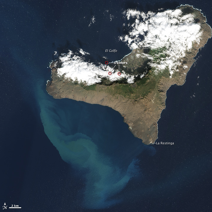
So, what has started in El Hierro is a new Surtseyan eruption, just of shore of El Pinar, a new volcano has been spewing lava and ash into the water column, along with a range of noxious gases. It is however, quite incredibly beautiful:
This satellite image shows the blue-green swirls of volcanic particles and ash mixing with the waters to the west of the Island, the three red dots, circle the epicentre of recent earthquakes on the north coast of the island (image belongs to the NASA Earth Observatory website):
So, what does this mean? Well, the eruption is unusual, as it has persisted for nearly three months, and it could continue and break the surface and become subaerial. At the moment, it is a typical Surtseyan style eruption, named after the Island of Surtsey, part of the Icelandic Rift system. This island formed in 1963, with eruptions persisting for three years, and giving its name to the "Surtseyan" eruption style. The initial phase was similar to El Hierro, but the Island of Surtsey was only preserved when the eruption ceased to be Phreato-magmatic, and lava sealed the surface to ensure the Island will be around until at least 2100. This is a new word for many fo you, a Phreatic eruption is one where the explosions are created by water interacting with the eruptive centre and producing stea, which drives a violent eruption of volcanic fragments and ejectiles. Phreato-magmatic, is where the volcano produces magma, which creates a violent eruption, often producing large eruption columns, and common in any sub-marine eruption in the first phase. Once the Island of Surtsey had breached the surface, and built up enough height to overcome the interaction with waves, the eruption style changed to a more typical basaltic eruption with fire fountains and small lava flows, creating a more stable island, that would resist the onslaught of the North Atlantic waves (You can read a summary of the eruption here). There is also an excellent article written by Erik Clemetti, an assistant Professor of Geology, on Hydro Volcanism with a thorough explanation of water/Magma mixing and some great case study pictures.
Back to El Hierro, the future may be shortlived, possibly only a few years, unless lava breaches the surface of the sea and builds an Island. In which case, it would be likely to follow the route of Surtsey, where subsidence into the crust, and erosion would lower the height, but build coastal depositional features such as this Spit that has been built at Surtsey over the last 50 years:
The island is now a UNESCO world heritage site, and has been studied since it first broke the surface yielding volumes of information about the rate of succession taking place on the island. There are now 30 established species, 69 have been counted in total, and 2-5 new species a year are introduced through a combination of driftwood, bird Guano and travelling insects. A soil has started to form, and the island is home to many seals, and hence regularly patrolled by Orcas. Over time, the island will erode, leaving behind a magma chamber, which will be more resistant due to slower cooling, and the island will eventually look like one of the many other small islands in the Vestmannaeyjar (West Man Islands), of which Heimay, which you have studied and some of you will be visiting, is part:
In a recent update, another island has been born in the Red Sea, the small group of islands owned by Yemen, known as the Zubair group, saw a new island breach the surface in December, information is still sparse, but this is part of the rifting process beneath the Red Sea, that extends through the Rift Valley, and is infact a stage or two further along in the Wilson Cycle than the Rift Valley is at the moment:
So, two new islands to keep an eye on over the coming months, as well as highly speculated and potentially catastophic eruption of Katla (remember Icelandic volcanoes are seasonal, they like to erupt in spring when isostatic pressure is relieved by the ice melt, and creates space in the magma chamber, which theoretically can destabilise the volcano). Icelanders refer to both Hekla and Katla as being "Pregnant" or heavily overdue in terms of eruptive frequency, so watch this space! (Or, more accurately, European airspace).


No comments:
Post a Comment