Showing posts with label Essays. Show all posts
Showing posts with label Essays. Show all posts
Wednesday, 2 May 2012
Tectonics Revision
Dear All
Tonights session is on tectonic theory, so everything connected to plate tectonics, types of volcanoes, earthquake theory, hotspots and continental drift. Please submit questions in advance if you cannot make it alter, the session starts at 730, and will run for as long as we need to, as there was no work shop on tuesday lunchtime.
Please remember, that yout questions do not appear automatically, only when I poublish them! So you may need to be patient as i organise your answers to make the session more logical.

Friday, 20 April 2012
Globalisation Revision Session Weds 25th April
Dear All,
Please use the form below to send in your questions on Globalisation. This session will start at at 7:30 on Wednesday evening, and YOUR QUESTIONS WILL NOT APPEAR!!! I have publishing control, so I will get through all of them, but in order and only when the event starts. It will run for about an hour, and the section of the syllabus to be covered is produced below:
Global social and economic groupings
The concept of the North/South divide, and its relationship to the development continuum.
Reasons for the social and economic groupings of nations, with particular reference to the European Union.
The consequences of the groupings of nations.
Aspects of globalisation Transnational corporations (TNCs): characteristics and spatial organisation. Reasons for the growth and the spatial organisation of transnational corporations (TNCs).
Case study of one TNC should be undertaken.
Social, economic and environmental impacts of TNCs on their host countries, and their countries of origin.
Development issues within the world (each to be studied with reference to contrasting areas of the world) “Trade versus aid”. “Economic sustainability versus environmental sustainability”. “Sustainable tourism, myth or reality”
.
Global social and economic groupings
The concept of the North/South divide, and its relationship to the development continuum.
Reasons for the social and economic groupings of nations, with particular reference to the European Union.
The consequences of the groupings of nations.
Aspects of globalisation Transnational corporations (TNCs): characteristics and spatial organisation. Reasons for the growth and the spatial organisation of transnational corporations (TNCs).
Case study of one TNC should be undertaken.
Social, economic and environmental impacts of TNCs on their host countries, and their countries of origin.
Development issues within the world (each to be studied with reference to contrasting areas of the world) “Trade versus aid”. “Economic sustainability versus environmental sustainability”. “Sustainable tourism, myth or reality”
.
Wednesday, 18 April 2012
Development Revision Workshop
Hello Readers,
Tonights topic is development, so please have some questions ready, remember, your questions will not appear immediately, I publish them when i am logged in and ready to answer each in turn, so please be patient, and of course, you can replay this workshop at anytime up until the exam.
Next weeks topic will be Globalisation, followed by Tectonic Theory, then Case studies, Climatic Case studies, and finally, Climate Change. You will be able to submit questions for these workshops in advance, I shall see you at 7:30!
Tonights topic is development, so please have some questions ready, remember, your questions will not appear immediately, I publish them when i am logged in and ready to answer each in turn, so please be patient, and of course, you can replay this workshop at anytime up until the exam.
Next weeks topic will be Globalisation, followed by Tectonic Theory, then Case studies, Climatic Case studies, and finally, Climate Change. You will be able to submit questions for these workshops in advance, I shall see you at 7:30!
Tuesday, 17 April 2012
Holderness Case Study
Dear Lower Sixth!
Here is the PP from todays lesson:
The Holderness Coastline
Your two major case studies for the coastal module are Holderness and Lyme Regis, where for both, you need to understand the reasons for, and the methods which have been used for protection. For both, the focus is on coastal erosion and management, and the area is Holderness in East Yorkshire. This is one of the most rapidly eroding coastlines in the UK, and can retreat as fast as 2m a year. The stretch of coastline you will be studying runs from Flamborough Head in the North, to Spurn Point i the South, the sediment underlying much of Yorkshire is Glacial till, and there are high grounds to the West which mark the western limit of Ice sheets during the last ice age.



This is an excerpt from a geography revision forum on the topic:
FOR Build rock groyne - trap sand at Mappleton - southern coast and farms destroyed
A new development is that permission has been given for a huge offshore wind farm just offshore from Spurn

Here is the PP from todays lesson:
The Holderness Coastline
So, what is coastal erosion? Let the Environment Agency explain!
Rock type is important, Till is a very immature rock, it forms under ice sheets and in Yorkshire is as young as 50 000 years old. The rock is soft, unconsolidated and composed of mud's and some sands with pebbles in it:
As such, the rock is very easy to erode, particularly over the winter when wave strength is at its highest, as seen in this short clip of the waves over winter breaking against the soft till:
There are some good intro videos to the case study already made for us, so here's a good basic one:
This is an excellent clip showing a time lapse photo project over a year in Yorkshire showing how much erosion and deposition takes place:
Why is this such a problem for Holderness? Well, you will get plenty from the video notes, including a rather interesting lady who loses her cows over the edge of the cliff. But Holderness is a real tourist honeypot site, there are numerous holiday parks and mobile home sites right on the coast, unfortunately they are at serious risk and many have already been lost to the sea:
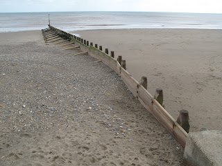
There are of course defences in place, but many are now ageing and in need of replacement, such as these groynes at Hornsea which are not overly attractive to tourists wishing to use the beach:
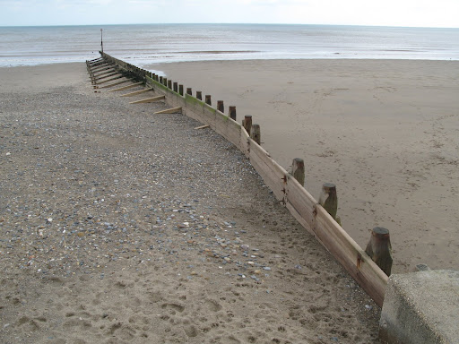
Yet, groynes are a relatively simple form of defence and the tourists would rather have a beach with groynes than none! They do however cause Terminal Groyne Syndrome, a rather painful affliction if you are a beach, which sees the sand piling up in some areas, and therefore being depleted in others (remember sediment cells are systems). The worst example of this is Mappleton, and it has resulted in certain areas of the coastline being protected through an aggressive Hold the line strategy, and some being lost through managed retreat with the creation of the five new bays.
The decision has been taken to defend Mappleton at the expense of the down drift towns such as Cowden (The former location of the Earle Farm which has now largely fallen into the sea).
This clip is part of the Blue Peter from 1994 that focused on Mrs Earle loosing her farm to the sea, much of this farm has now gone, as a result of the protection installed at Mappleton to protect the road and the village. This is an excellent example of a cost-benefit analysis, it cost less to build two groynes at £1 million each in Mappleton, than to relocate the road and the residents, but the Earle farm paid the price in 1997. To add to their misery, they were then asked to pay for the demolition costs at their farm as the building was slowly falling into the sea. Quite often, insurance companies do not pay for claims as a result of what is known as a "gradually operated cause", as in coastal erosion, so for many of these homes at risk from receding coastlines, there is no compensation. This is an excerpt from a geography revision forum on the topic:
- Coastal erosion - Holderness coast, Yorkshire. Tip: Remember the shape of the coastline as the man with a beard
- Main rock is boulder clay so cliffs are unstable. Other main rock is chalk
- Cliffs retreat by 2m a year
- 50 villages that exist during the medieval times are lost today
- 5 km of land already lost
- Major features (in order from north to south) – Flamborough Head, Holderness Coast and Spurn Head
- The Great Debate – Protect Mappleton/ B 1242?
- Problem: Protecting an area of land always mean greater pressure and coastal erosion on neighbouring stretches of coast
FOR Build rock groyne - trap sand at Mappleton - southern coast and farms destroyed
- One example would be Sue Earl, a farmer in Great Cowden. Although she had lost a lot of land every year, she was determined to keep the farm running. Eventually the sea will claim the whole farm so she had to give up, especially when the farmhouse went too.

Your comparative case study will be Lyme Regis, which we will cover on the trip, but in order to prepare yourself here is a video explaining why Lyme is an important site, not only for the town itself, but also for the South West:
Monday, 5 March 2012
Atmosphere and Circulation help
Dear All
Our current topic (Climate for those who dont go to Huish!) is widely accepted to be a little bit challenging, so I thought a special blog post on how to learn about this in a different way might be appreciated. So, first of all, a recap on the most basic rules of circulation in the atmosphere, if you dont want to read, the BBC have produced a really outstanding TV show, called "Orbit" which you can watch here, I would consider this a really excellent way to spend an hour, as it makes the entire start of the module easy and is very visual. They even have a blog centre for more reading, but in the mean time:
1. The spin of the earth:
Earth spins towards the East, if you are attached to the surface (Continents, people, trees etc) then you do not feel this effect, but, for all gases and liquids, the spin of the earth to the East, deflects surface flows towards the West. Hence, all ocean currents, surface winds, hurricanes, are pushed to the west. If the earth did not have any continents, the oceanic currents would just move around the globe, from east to west, but, the continents complicate the issue, and force ocean currents to deflect North, in the Northern Hemisphere, and South, in the Southern hemisphere, along the Eastern edges of the continents.

2. The tilt of the earth:
We tilt at an angle of 23.4 degrees away from an imaginary line that is perpendicular to our orbital plane. Our tilt, or obliquity, does not alter as we move around the sun, therefore, over our summer time, we are tipped towards the sun, summer starting during the spring equinox, through to the summer solstice and on to the september equinox, when we enter winter, as we start to tip away from the sun, reaching our maximum distance, during the winter solstice, or as you may know it, as December the 22nd.
 This tilt, is what brings us the seasons, and what causes the ITCZ to move over the course of the year.
3. Convection:
This really is a key concept in Earth Sciences as a whole. The basic principle, is that anything hot, rises, until it hits an impenetrable layer, at which it must split, and flow laterally along this boundary, loosing heat to its surroundings as it does so. Once cold, it must sink, as it has become more dense, it then hits another layer, and diverges, some goes back to the source of the heat (where there will be a vacuum as material is constantly rising), and some heads in the opposite direction.

You have come across this before:

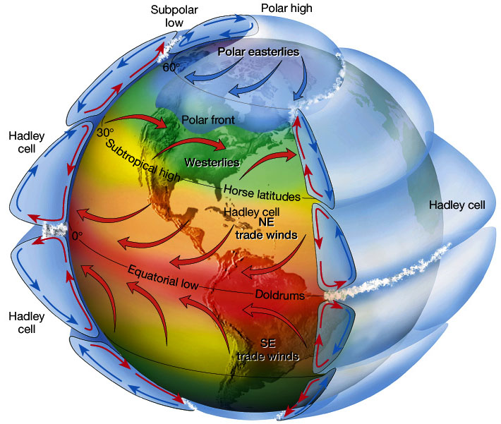
Once you factor in the 3D nature of the planet, and the atmosphere, along with the fact that we are so big, the cells are split into three, you have the global circulation model:
 4. With or against Coriolis?
The Coriolis effect, is just the name we give to anything that is affected by the spin of the earth, you have come across it with tides in the Lower Sixth. The key principle to remember, is that anything that moves towards the equator, is slowed by the Coriolis effect, and therefore is always deflected to the West. If the opposite occurs, if a movement of liquid or gas moves towards a pole along the surface, it is boosted by Coriolis, and moves with the turn of the earth.
This means, that winds in the Ferrel cell, on the surface, blowing towards the poles, blow from the SW up towards the poles (Or down, if you are below the equator).

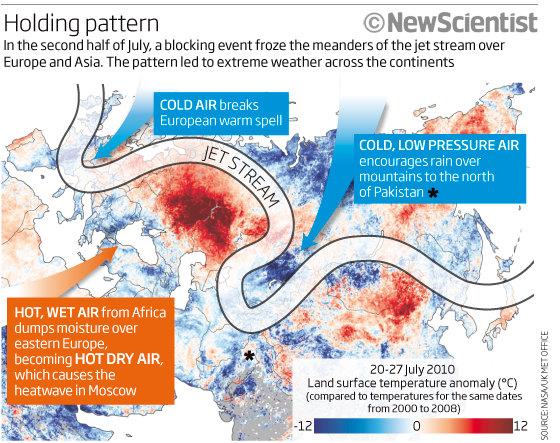
If we are talking Jet streams and Rossby waves, this difference in speed is what controls the path of Anticyclones and depressions beneath the junction between the Ferrel and the Polar cells. These regions are often referred to as the Horseback latitudes. Hence, when the meanders on the Jet stream (which we call Rossby Waves), start to head towards the equator, they are slowed, and therefore pressure builds up in the upper Atmosphere, and all the excess air has to start moving downwards, ie towards the surface, this is what is found in the ridges of the waves (Closest to the poles), whereas in the troughs, the air starts to accelerate towards to poles, leaving behind high altitude low pressure, therefore, to fill the void, air has to be sucked up from the surface, creating a low pressure system, more commonly called a depression:

There is an excellent animation of this on the TV show recommended. This passage can sometimes get stuck, as happened in July 2008, and December 2010, as this diagram explains:

5. The ITCZ:
This is the driving force, which starts the tri-cellular model, the ITCZ stands for Inter Tropical Convergence Zone, literally, the place where the surface winds of the Hadley cell come together, and where the most intense heating of the earths surface takes place. It can easily be seen on most satellite images:

It is not a straight line, none of the boundaries between the cells are, and it moves as the earth rotates around the sun. In our winter time, it is more southerly, and over our summer time, more northerly. Where it crosses continents that sit beneath the two extremes, it causes a seasonal reversal of the winds, and this change, brings about the Monsoons:


In India, this results in the onset of the seasonal rains, this dictates plant life, agriculture and water storage, and is not always reliable. It arrives at different times of the year, depending on how far away from the Western Seaboard you are, and can be mapped like this:

The Monsoon brings between 4 months and 6 weeks of intense heavy rainfall, and along with the UK climate, is your major case study of a climatic zone.
So, 5 rules, or key things to remember, and an excellent TV show to watch, the next episode is on next sunday, the 11th, at 9 on BBC 2 - put it in your diary!
Our current topic (Climate for those who dont go to Huish!) is widely accepted to be a little bit challenging, so I thought a special blog post on how to learn about this in a different way might be appreciated. So, first of all, a recap on the most basic rules of circulation in the atmosphere, if you dont want to read, the BBC have produced a really outstanding TV show, called "Orbit" which you can watch here, I would consider this a really excellent way to spend an hour, as it makes the entire start of the module easy and is very visual. They even have a blog centre for more reading, but in the mean time:
1. The spin of the earth:
Earth spins towards the East, if you are attached to the surface (Continents, people, trees etc) then you do not feel this effect, but, for all gases and liquids, the spin of the earth to the East, deflects surface flows towards the West. Hence, all ocean currents, surface winds, hurricanes, are pushed to the west. If the earth did not have any continents, the oceanic currents would just move around the globe, from east to west, but, the continents complicate the issue, and force ocean currents to deflect North, in the Northern Hemisphere, and South, in the Southern hemisphere, along the Eastern edges of the continents.

2. The tilt of the earth:
We tilt at an angle of 23.4 degrees away from an imaginary line that is perpendicular to our orbital plane. Our tilt, or obliquity, does not alter as we move around the sun, therefore, over our summer time, we are tipped towards the sun, summer starting during the spring equinox, through to the summer solstice and on to the september equinox, when we enter winter, as we start to tip away from the sun, reaching our maximum distance, during the winter solstice, or as you may know it, as December the 22nd.

3. Convection:
This really is a key concept in Earth Sciences as a whole. The basic principle, is that anything hot, rises, until it hits an impenetrable layer, at which it must split, and flow laterally along this boundary, loosing heat to its surroundings as it does so. Once cold, it must sink, as it has become more dense, it then hits another layer, and diverges, some goes back to the source of the heat (where there will be a vacuum as material is constantly rising), and some heads in the opposite direction.

You have come across this before:
Once you factor in the 3D nature of the planet, and the atmosphere, along with the fact that we are so big, the cells are split into three, you have the global circulation model:
The Coriolis effect, is just the name we give to anything that is affected by the spin of the earth, you have come across it with tides in the Lower Sixth. The key principle to remember, is that anything that moves towards the equator, is slowed by the Coriolis effect, and therefore is always deflected to the West. If the opposite occurs, if a movement of liquid or gas moves towards a pole along the surface, it is boosted by Coriolis, and moves with the turn of the earth.
This means, that winds in the Ferrel cell, on the surface, blowing towards the poles, blow from the SW up towards the poles (Or down, if you are below the equator).

If we are talking Jet streams and Rossby waves, this difference in speed is what controls the path of Anticyclones and depressions beneath the junction between the Ferrel and the Polar cells. These regions are often referred to as the Horseback latitudes. Hence, when the meanders on the Jet stream (which we call Rossby Waves), start to head towards the equator, they are slowed, and therefore pressure builds up in the upper Atmosphere, and all the excess air has to start moving downwards, ie towards the surface, this is what is found in the ridges of the waves (Closest to the poles), whereas in the troughs, the air starts to accelerate towards to poles, leaving behind high altitude low pressure, therefore, to fill the void, air has to be sucked up from the surface, creating a low pressure system, more commonly called a depression:
Trough: pressure is lower in a trough than to the west and east
Ridge: pressure is higher in a ridge than to the west and east

5. The ITCZ:
This is the driving force, which starts the tri-cellular model, the ITCZ stands for Inter Tropical Convergence Zone, literally, the place where the surface winds of the Hadley cell come together, and where the most intense heating of the earths surface takes place. It can easily be seen on most satellite images:

It is not a straight line, none of the boundaries between the cells are, and it moves as the earth rotates around the sun. In our winter time, it is more southerly, and over our summer time, more northerly. Where it crosses continents that sit beneath the two extremes, it causes a seasonal reversal of the winds, and this change, brings about the Monsoons:
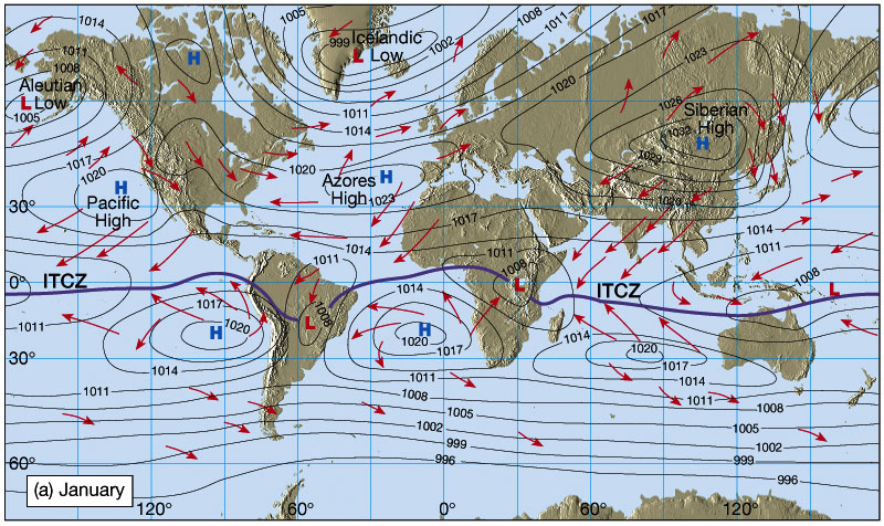
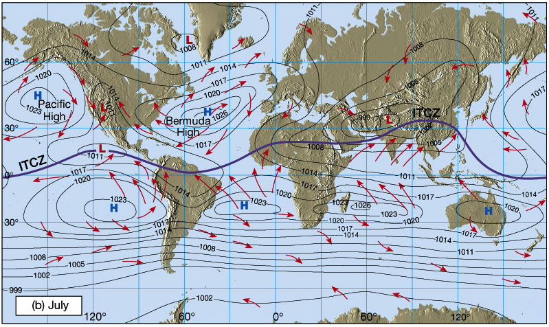

The Monsoon brings between 4 months and 6 weeks of intense heavy rainfall, and along with the UK climate, is your major case study of a climatic zone.
So, 5 rules, or key things to remember, and an excellent TV show to watch, the next episode is on next sunday, the 11th, at 9 on BBC 2 - put it in your diary!
Tuesday, 13 September 2011
Upper Sixth Workshop: Essays and an Introduction to Colonialism.
Dear Geographers!
Welcome back to the Upper Sixth, it has been a long holiday, and a while since the last blog post but this year we have some exciting new developments to help you with your reading for the subject.
Firstly, every tuesday night, from 530 on, for about an hour, there will be a live extension workshop here, the new development, is that you will be able to hear me through the player on the blog, and you will be able to ask any questions about that weeks topic through the CoverItLive function. This means that you do not need an account, or to sign in, you ask a question about the weeks lessons by typing, and I will answer through the miracles of live radio streaming!
This has been developed as a means to allow us to target the Upper Sixth at a more convenient time, and you can replay the session. If you cannot make the session, you should be able to submit a question through the Ticker on the blog and when the event starts I will answer all questions!
Other developments:
We will be having a series of guest bloggers in throughout the year, people who are either ex-students now doing Masters of PhD's in relevant fields, keep an eye out for their articles! If you know of anyone working in a Geographical, or even better, Geological field, please out them in touch with me if they would like to contribute!
Lastly for now, if you are considering an earth science related degree, please do let me know, as we are always on the look out for more student bloggers, this would mean that as an enrichment, you put together your own blog, commenting on current affairs, writing up case studies you come across, etc. This will allow you to show your universities you are a dedicated earth science student, and has been well received in the past by university interviewers. Remember, competition for places is on the rise, and this is a good way to make yourself stand out from the crowd!
Come back to this page at 530 for the workshop, you should be able to access it through a 3g smart phone, but let me know if there are any problems!
In the meantime, if you have a question about the essay, please leave it here:
"To what extent are the low levels of development in Sub-Saharan Africa a result of European Colonialism"
Due: week commencing 26th September.
Welcome back to the Upper Sixth, it has been a long holiday, and a while since the last blog post but this year we have some exciting new developments to help you with your reading for the subject.
Firstly, every tuesday night, from 530 on, for about an hour, there will be a live extension workshop here, the new development, is that you will be able to hear me through the player on the blog, and you will be able to ask any questions about that weeks topic through the CoverItLive function. This means that you do not need an account, or to sign in, you ask a question about the weeks lessons by typing, and I will answer through the miracles of live radio streaming!
This has been developed as a means to allow us to target the Upper Sixth at a more convenient time, and you can replay the session. If you cannot make the session, you should be able to submit a question through the Ticker on the blog and when the event starts I will answer all questions!
Other developments:
We will be having a series of guest bloggers in throughout the year, people who are either ex-students now doing Masters of PhD's in relevant fields, keep an eye out for their articles! If you know of anyone working in a Geographical, or even better, Geological field, please out them in touch with me if they would like to contribute!
Lastly for now, if you are considering an earth science related degree, please do let me know, as we are always on the look out for more student bloggers, this would mean that as an enrichment, you put together your own blog, commenting on current affairs, writing up case studies you come across, etc. This will allow you to show your universities you are a dedicated earth science student, and has been well received in the past by university interviewers. Remember, competition for places is on the rise, and this is a good way to make yourself stand out from the crowd!
Come back to this page at 530 for the workshop, you should be able to access it through a 3g smart phone, but let me know if there are any problems!
In the meantime, if you have a question about the essay, please leave it here:
"To what extent are the low levels of development in Sub-Saharan Africa a result of European Colonialism"
Due: week commencing 26th September.
Thursday, 28 April 2011
Essays workshop from today
Structuring Answers
Human essays usually focus on Impacts/issues/consequences/reasons and can nearly always be structured by a paragraph each on Socio-Economic, Political and Environmental. This includes essays on physical topics with a human element, such as flooding or protection.
If it is Rivers and regarding processes it can normally be split into upper/middle/lower courses
For either rivers or Coasts, if it is a purely physical question, such as the formation of a landform, or changes associated with sea level change, it needs to be a logical explanation, using the right terminology, and set out in stages.
This really is the key to doing well in eessays, you need to make sure that you are using geographical words in order to secure the top marks in all questions, not just essays!
In terms of further help, it was suggested that seeing some model answers would be the best way for you to understand structure. As such, you can vote on the essays you would most like to read and I will write them. If there are enough people interested, i will write two of the essays below this weekend for you to read. You need to vote on FB for the number essay you want.
1. Some housing and transport systems in the UK are being designed to reduce energy use. Discuss how the importance of such schemes is reducing the countries contribution to global warming(126)
2. Describe and explain the impact of the use of fossil fuels on the environment (100)
3. Discuss the view that nuclear power can be managed to that it is an environmentally sustainable source of energy (70)
4. Describe and explain why there is no single form of renewable energy that would satisfy a countries complete energy needs.
5. With reference to a named country, evaluate attempts to manage population change(124)
6. Outline and comment on the economic and political consequences of population change (97)
7. “for better or worse” discuss how population change can affect the character of rural and urban areas (66)
8. Ageing populations represent the greatest concern to populations experiencing change. To what extent do you agree.
9. With reference to one or more case studies of coastal management, discuss whether the benefits outweigh the costs (122)
10. With specific reference to a case study of coastal erosion, asses the relative importance of its physical and socio-economic consequences (94)
11. Using a case study, assess the causes and consequences of coastal flooding (62)
12. Describe and explain the coastal landforms resulting from sea level change
13. Describe and explain the development of meanders (120)
14. Describe and explain the formation of landforms resulting from rejuvenation (92)
15. Channel characteristics such as cross profile, wetted perimeter, hydraulic radius, roughness and channel efficiency change downstream. Describe and explain how channel characteristics change downstream (59)
16. Flooding represents the greatest risk to the poorest parts of the worlds population. Discuss.
SO, cast your votes, write some of your own and stay on top of your revision!
Monday, 28 March 2011
Holderness Coastline
Dear Lower Sixth!
Welcome to an online post especially for you to help you with your work whilst we are in Iceland. You will be starting your first major case study of this module, the focus is on coastal erosion and management, and the area is Holderness in East Yorkshire. This is one of the most rapidly eroding coastlines in the UK, and can retreat as fast as 2m a year. The stretch of coastline you will be studying runs from Flamborough Head in the North, to Spurn Point i the South, the sediment underlying much of Yorkshire is Glacial till, and there are high grounds to the West which mark the western limit of Ice sheets during the last ice age.
This is an excerpt from a geography revision forum on the topic:
FOR Build rock groyne - trap sand at Mappleton - southern coast and farms destroyed
A new development is that permission has been given for a huge offshore wind farm just offshore from Spurn
Welcome to an online post especially for you to help you with your work whilst we are in Iceland. You will be starting your first major case study of this module, the focus is on coastal erosion and management, and the area is Holderness in East Yorkshire. This is one of the most rapidly eroding coastlines in the UK, and can retreat as fast as 2m a year. The stretch of coastline you will be studying runs from Flamborough Head in the North, to Spurn Point i the South, the sediment underlying much of Yorkshire is Glacial till, and there are high grounds to the West which mark the western limit of Ice sheets during the last ice age.
So, what is coastal erosion? Let the Environment Agency explain!
Rock type is important, Till is a very immature rock, it forms under ice sheets and in Yorkshire is as young as 50 000 years old. The rock is soft, unconsolidated and composed of mud's and some sands with pebbles in it:
As such, the rock is very easy to erode, particularly over the winter when wave strength is at its highest, as seen in this short clip of the waves over winter breaking against the soft till:
There are some good intro videos to the case study already made for us, so here's a good basic one:
This is an excellent clip showing a time lapse photo project over a year in Yorkshire showing how much erosion and deposition takes place:
Why is this such a problem for Holderness? Well, you will get plenty from the video notes, including a rather interesting lady who loses her cows over the edge of the cliff. But Holderness is a real tourist honeypot site, there are numerous holiday parks and mobile home sites right on the coast, unfortunately they are at serious risk and many have already been lost to the sea:
There are of course defences in place, but many are now ageing and in need of replacement, such as these groynes at Hornsea which are not overly attractive to tourists wishing to use the beach:
Yet, groynes are a relatively simple form of defence and the tourists would rather have a beach with groynes than none! They do however cause Terminal Groyne Syndrome, a rather painful affliction if you are a beach, which sees the sand piling up in some areas, and therefore being depleted in others (remember sediment cells are systems). The worst example of this is Mappleton, and it has resulted in certain areas of the coastline being protected through an aggressive Hold the line strategy, and some being lost through managed retreat with the creation of the five new bays.
The decision has been taken to defend Mappleton at the expense of the down drift towns such as Cowden (The former location of the Earle Farm which has now largely fallen into the sea).
This clip is part of the Blue Peter from 1994 that focused on Mrs Earle loosing her farm to the sea, much of this farm has now gone, as a result of the protection installed at Mappleton to protect the road and the village. This is an excellent example of a cost-benefit analysis, it cost less to build two groynes at £1 million each in Mappleton, than to relocate the road and the residents, but the Earle farm paid the price in 1997. To add to their misery, they were then asked to pay for the demolition costs at their farm as the building was slowly falling into the sea. Quite often, insurance companies do not pay for claims as a result of what is known as a "gradually operated cause", as in coastal erosion, so for many of these homes at risk from receding coastlines, there is no compensation. This is an excerpt from a geography revision forum on the topic:
- Coastal erosion - Holderness coast, Yorkshire. Tip: Remember the shape of the coastline as the man with a beard
- Main rock is boulder clay so cliffs are unstable. Other main rock is chalk
- Cliffs retreat by 2m a year
- 50 villages that exist during the medieval times are lost today
- 5 km of land already lost
- Major features (in order from north to south) – Flamborough Head, Holderness Coast and Spurn Head
- The Great Debate – Protect Mappleton/ B 1242?
- Problem: Protecting an area of land always mean greater pressure and coastal erosion on neighbouring stretches of coast
FOR Build rock groyne - trap sand at Mappleton - southern coast and farms destroyed
- One example would be Sue Earl, a farmer in Great Cowden. Although she had lost a lot of land every year, she was determined to keep the farm running. Eventually the sea will claim the whole farm so she had to give up, especially when the farmhouse went too.
A new development is that permission has been given for a huge offshore wind farm just offshore from Spurn
Your comparative case study will be Lyme Regis, which we will cover on the trip, but in order to prepare yourself here is a video explaining why Lyme is an important site, not only for the town itself, but also for the South West:
Work to do this week:
- Watch the video on Holderness and Spurn Head
- Read the module booklet pages 48 to 54
- Complete the side of the sheet with the map on it.
- On the reverse, make bullet point notes on considerations for coastal management split into the four categories (Social, Economic, Political, Environmental) we will add to these when I return.
- Answer the past paper questions on pages 55 and 56 for me to take in next Tuesday
I know we have not yet covered sand dunes and salt marshes, but you need an introduction to management before the field trip to Lyme Regis next week, on that note, please sign up asap, the Thursday and Friday sessions are filling up, and the trip is an important part of your course.
Any questions please have a word with Richard!
Sunday, 27 March 2011
Mass Movement 101
To all Lower sixth geologists and geographers of both years!
You have recently studied mass movement as part of your course, which is of course the downslope movement of rock and soil under the influence of gravity. Here is an explanation of the key types of mass movement with some videos and after uch request, this post will be bullet pointed for ease of reading, though, personally I feel you need to be reading and making your own bullet points!!
Here is a good intro and a full episode of "When Nature Strikes Back" on Landslides:
Rock Falls
- dry movements
- very fast
- typical on hard rocks
- more common on rocks that are heavily fractured and jointed as these can be exploited
- key weathering process = freeze thaw
- Triggers = Earthquakes, heavy rain, eruptions,
- Anthropogenic Influences = undercutting, traffic vibrations
This video is an explanation of the hazard at Yosemite National Park, it is very clear on the risks, why Yosemite is prone to falls, and about how to assess impacts and detecting falls:
You may have seen this one in class, but here's how the Norwegians approach mass movement management:
Testing your rock throwing capability:
The Swiss approach - useful for management:
A very technical rockfall management barrier:
Landslides
This is the downslope movement of a large block of material that moves as a coherent mass, ie it retains its internal structure until hitting the base of the slope and fracturing into smaller pieces. It is more common over wet periods, and on steep slopes, and often observed on coastlines.

- Relatively dry movements, prompted by water
- Relatively fast
- typical on relatively hard rocks, often those that dip towards the base of the slope
- more common on rocks that are heavily fractured, steeply dipping and easily laden with water
- key weathering process = water layer weathering, hydration, freeze thaw
- Triggers = Earthquakes, heavy rain, eruptions, undercutting by the sea
- Anthropogenic Influences = undercutting, traffic vibrations, building on steep slopes, terminal groyne syndrome, climate change
This fist video is of a region that has been undercut to allow road access, which is clear at the end, and has prompted a massive landslide. It was triggered by heavy rains, but you can clearly see some of the trees remaining upright until the landslide hits the bottom of the slope:
This next video is of a huge landslide that occurred in a malaysian mine, it was predicted but you can clearly see how once it starts, the slope is destabilised and more and more material becomes entrained in the flow:
This Landslide in Italy last year, was spectacularly caught on camera, much of the material remains intact, and it looks like a flowing liquid, but, as with the malaysian video above, there is very little moisture in here, it is nearly a pure gravity driven movement:
Why we shouldn't deforest our rain forests reason number 1003:
Another swiss video, excellent for monitoring and management of landslides! Very informative and some good shots of testing barriers
And here is a barrier being tested:

So, in short, landslides can be managed through structural responses, ie building retaining fences, careful monitoring and avoiding potentially dangerous situations such as undercutting and building on steep slopes.
Slumps
These are very hard to catch on camera, they are similar to a landslide, but the slumped rock remans intact, just resting at a lower angle with the beds and trees tipping back towards the original cliff profile. The largest of the UK's slumps is at Lyme Regis, which you will see on the fieldtrip.

- Fairly wet, and relatively fast movements
- Material does not travel far from source
- typical on soft rocks, often those that are unconsolidated or weakly consolidated
- most common on muds and clays on the coast
- key weathering process = hydration
- Triggers = Earthquakes, heavy rain, eruptions, ash fall, saturation, snow melt
- Anthropogenic Influences = terminal groyne syndrome, climate change, building on cliff tops.

Here is a photo of a rotational slump from Barton on Sea, note the surface is still vegetated, just at a lower position than the rest of the cliff:

Unfortunately, i cant find any videos of a slump in progress, if you know if one, post a link below!
Mudflows/Debris Flows
This is a considerably wetter movement than any of the others, here water is the key, in that the excess water equates to extra weight, and the force of gravity acting on the slope causes the rock face to loose all internal structure and to mix with the water to form a dense fluid capable of transporting large boulders.

- Very wet movements, prompted by water saturating pore spaces
- Relatively fast, but speed slows with change in slope and distance from source
- typical on soft rocks, often those that are unconsolidated
- most common on muds and clays
- key weathering process = hydration
- Triggers = Earthquakes, heavy rain, eruptions, ash fall, saturation, snow melt
- Anthropogenic Influences = terminal groyne syndrome, climate change building on cliff tops, forest fires
The first video gives a good idea of the movement of a debris flow, this is a flow on the Andes and clearly shows that even at slow speeds, mud flows can move large boulders through traction:
This second video is from California, a region used to debris flows, this one is caused by a forest fire which exposes the soil and with heavy rain and no support, the soil is easily entrained in surface runoff. Note the tractor at the end, I am not sure if he is meant to be there or not!
This shows an aggressive mud flow in Afghanistan prompted by snow melt, the region is clearly prepared/used to these events as the road is closed off and the gully well eroded:
In terms of management, debris flows can be identified before they start as the conditions that prompt them are fairly well understood. When this happens, barriers can be put in place as the following video explains:
They can be managed structurally, as this video of a barrier under construction shows:
Management
All Mass Movement can be managed through mitigation (lessening the hazard once it occurs) or management (trying to prevent it from happening). As every with geography, the basics for the region are:
- Education
- Hazard Mapping
- Land use Planning
- Evacuation Procedures
- Prediction
- Monitoring
Specifically for mass movement, the biggest enemy is water. Water can be removed through drainage, either surface or below. In places like Lyme Regis, where much of the cliffs are drained, this is done at great cost sub surface in order to preserve the attractions of the area.
Surface runoff needs to be managed as well as movement through the rock, and no coastal cliff can be controlled without taking into account the coastal as well as terrestrial processes, which is why when considering coastal management, we need to consider coasts as a constantly changing, over different time scales and working as a system, with inputs from both the land and the sea.
So, not quite bullet pointed all the way through, but a short video summary of different types of mass movement and their management. Post any questions below, remember for AS geography, all physical essays on the coast will need a mention of geology and the risks of different rock types. Mass movement for the A2 is a risk in most tectonically active regions and more of a risk in Developing countries.
See you all on Monday
Millie
Subscribe to:
Posts (Atom)